

How to See 3D View in Google Maps on Any Device
You're looking at a downtown you've never visited, zoomed in until the street names are readable, and everything still looks painted flat. You expected towers, shaded facades, and a sense of which building is taller. Instead you get rooftops on a sheet. That's the moment many people start hunting for a 3D button, tapping layers at random, and assuming their phone or browser is broken. Usually it isn't. You're mixing up three different features, or you're testing a place that doesn't have building models at all.
What 3D View in Google Maps Really Is
Say you search a busy downtown, zoom to block level, and wait for the towers to stand up. Nothing happens. The streets get larger, but the rooftops stay flat. That doesn't automatically mean you missed a setting. It often means you're expecting one feature while looking at another.
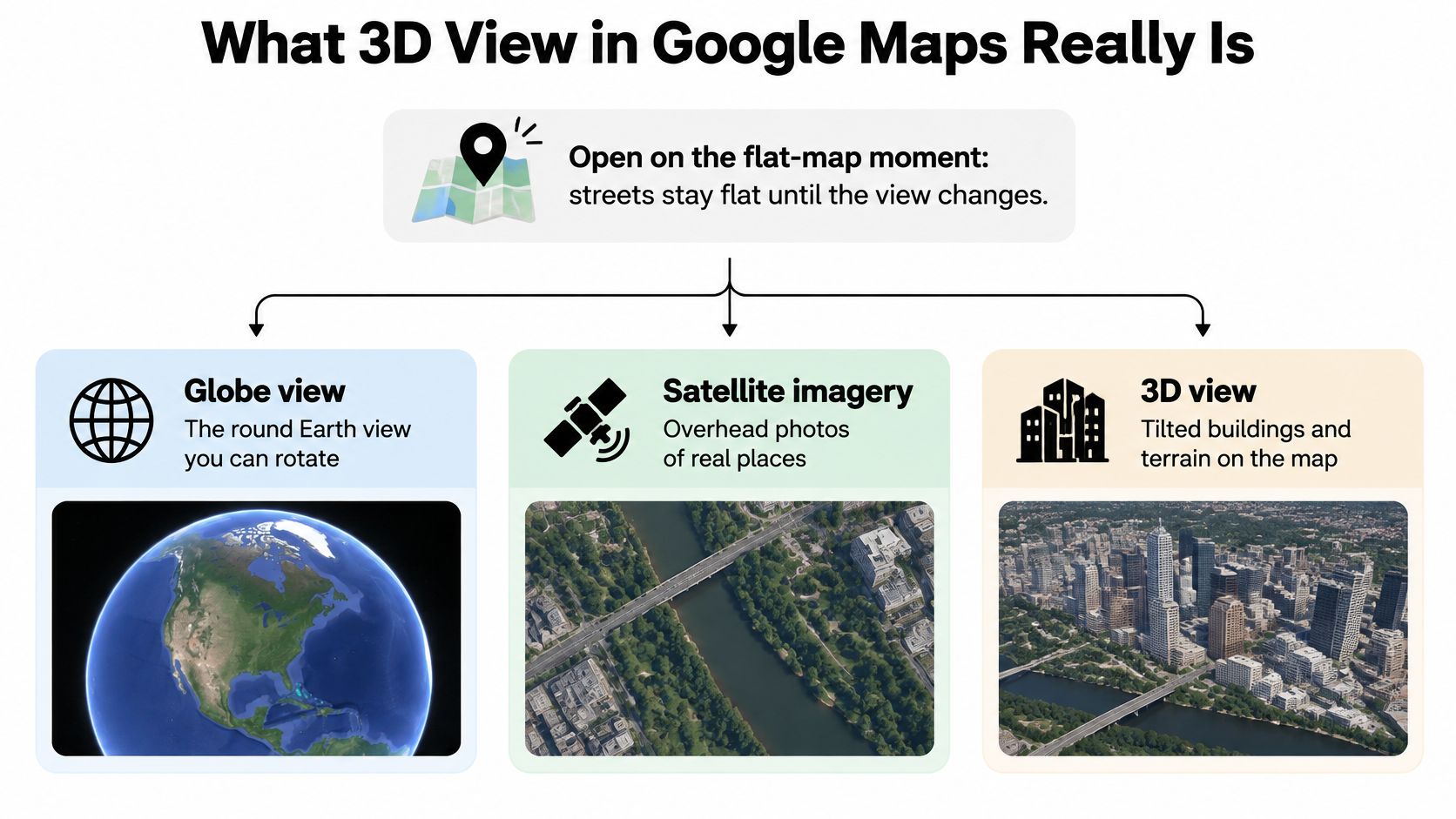
Three Features People Mix Up
- Globe view: The round Earth you see on desktop when you're fully zoomed out. You switch it on from Satellite, then Layers, then More. It changes the world view, not a single street.
- City 3D: Vertical building geometry that appears after a close zoom in a supported urban area. This is what users often mean when they ask how to see 3D view in Google Maps.
- Immersive View: A separate fly-through for selected places. It's not the everyday tilt control, and its absence doesn't mean ordinary 3D is broken.
The building models come from aerial photogrammetry, where overlapping aerial photographs are used to reconstruct surfaces in three dimensions. That's why one block can look sharp and current while the next looks dated or melted at the edges. Capture dates and imagery sources aren't uniform across a city.
Coverage is broad but not universal. Current Google documentation described in the Google Maps Platform blog on Earth imagery puts photorealistic 3D coverage across approximately 2,500 cities in 49 countries. A small town can pass every step correctly and still show only terrain because no mesh exists there.
Success test: Buildings gain height and sides, and tilt changes your camera perspective. If tilt only makes the flat picture bigger, 3D isn't active yet.
Keep that limit in mind when you move indoors, too. Outdoor meshes don't tell you where a gate, store, or clinic sits inside a complex, which is why Waymap's guide to Google Maps Indoors is useful context for readers who need interior orientation after they reach the building.
Where the 3D Control Lives on Each Device
Match your screen first. The biggest source of confusion is following desktop instructions on a phone, or hunting for a phone gesture menu on a laptop. Each surface turns 3D on differently, moves the camera differently, and gives you a different realistic result.
How to Turn On 3D by Device
| Device | How you turn 3D on | How you move the camera | What you should expect |
|---|---|---|---|
| Desktop web | Satellite, then Layers, More, Globe view, then the 3D icon by the compass | Scroll to zoom, drag to pan, on-screen tilt and rotate | Globe plus building meshes in covered cities |
| Android phone or tablet | Zoom in, then tilt; no Globe menu | Pinch to zoom, two-finger swipe up to tilt, twist to rotate | Tilted map and buildings only in covered cities |
| iPhone or iPad | Zoom in, then tilt; no Globe menu | Pinch to zoom, two-finger swipe up to tilt, twist to rotate | Same city limits as Android |
| Android Auto or CarPlay | No free 3D browsing control | Navigation glance only | Not useful for inspecting buildings |
| Google Earth web or app | Opens as a 3D globe | Full tilt, rotate, and zoom | Deeper terrain when Maps stays flat |
Desktop web is the only place with the full sequence. You need Satellite as the base, Globe view enabled under Layers and More, and the 3D icon beside the lower-right compass. Once that's on, the on-screen controls let you tilt and rotate without keyboard shortcuts. If you don't see that compass cluster, you're probably not in the right mode yet.
Phones work on touch, not menus. Android and iPhone or iPad don't use the Globe menu at all. You zoom close, then use a two-finger swipe upward to tilt the camera and a two-finger twist to rotate it. There's often no labeled 3D button to find, which is why people search the settings and come up empty.
What Each Screen Can Actually Show
Don't expect the same result everywhere. In a covered city, desktop and mobile can both show building meshes once you're zoomed to block level. Outside covered areas, you'll get a tilted satellite sheet or raised terrain, and that's the correct result for that place. The camera moved. The buildings do not have models to display.
Car screens are the wrong tool for this job. Android Auto and CarPlay are built for navigation glances while you drive, not for browsing facades or comparing building heights. If you're parked and trying to inspect a destination, pick up the phone or open a laptop instead.
Google Earth is your fallback. The web version and the app open as a 3D globe rather than a flat map with an optional tilt, so terrain and city models are the starting point. When Maps stays stubbornly flat for a coastline or a mountain approach, Earth often gives you the depth you wanted without extra toggles.
Use the laptop when you need the globe and a city model for planning, teaching, or a presentation. Use the phone when you're already on the street and only need the camera tipped so the facade in front of you matches the screen.
That choice rule saves time. Desktop gives you precise controls, a bigger frame, and easier rotation for comparing blocks. Mobile gives you speed and orientation where you're standing. Neither one creates buildings in a town that hasn't been modeled, and switching devices won't fix a coverage gap. Pick the screen that fits the task, then test it in a place you know is covered.
Turn On 3D View on Desktop Google Maps
Desktop is where how to see 3D view in Google Maps has a clear, repeatable sequence. Follow the clicks in order. If you skip the Satellite base or the Globe setting, the 3D control may be missing or the map will tilt without showing proper building geometry.
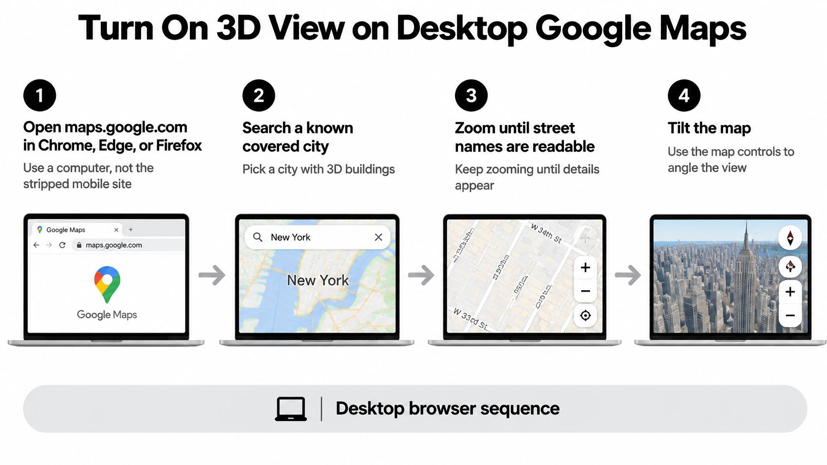
The Desktop Sequence in Order
- Open maps.google.com on a computer: Use Chrome, Edge, or Firefox. Don't use a stripped mobile site in a small browser window, because controls can be hidden or rearranged.
- Search a known covered city: Start with a large downtown rather than your home street. You need a test place where models almost certainly exist, so you can separate a settings problem from a coverage problem.
- Zoom until street names are readable: Keep scrolling in until individual blocks and building footprints separate. Building meshes don't appear at neighborhood or citywide zoom, even in covered places.
- Switch the base layer to Satellite: The 3D building layer sits on imagery. If you stay on the pale default road map, you won't get the same photorealistic result.
- Open Layers, choose More, and enable Globe view: This is the step people miss because it's buried one level deeper than the main layer choices.
- Select the 3D button near the lower-right compass: Look at the compass cluster, not the top search bar or the left panel. The control is small, and it's easy to scan past it.
- Drag, tilt, and rotate: Drag to pan across blocks. Use the tilt control to tip the camera toward street level, and use rotate so the streets align with the direction you care about.
The Globe setting matters for more than looks. According to Google Maps Help on viewing maps in 3D, in August 2018 Google changed the fully zoomed-out desktop experience to a 3D globe, replacing the earlier flat projection for global browsing. A globe keeps continents closer to their true relative shape, while a flat projection can significantly distort regions near the poles. That's why zooming out after you enable Globe view feels different from the old flat sheet.
Confirm It Worked Before You Explore
Don't judge success by whether the map moved. Judge it by geometry. Buildings should gain vertical sides and shadows instead of staying as flat satellite polygons pasted on the ground. Tilt should change perspective, so nearer buildings look larger and you can see facades, not only rooftops.
Try a simple check. Center a tall downtown block, tilt halfway, and rotate a quarter turn. If the same building shows a different face after rotation, you're looking at a model. If it looks like a photograph sliding under glass, you're still on flat imagery.
- Smooth zoom feels continuous: The view flows from globe to street without the old stepped jumps.
- Terrain has relief: Hills and valleys shade and rise as you tilt, instead of staying as color changes.
- Labels stay readable: Street names remain anchored while the camera angle changes.
Remember the coverage limit while you test. Detailed models aren't universal, so a small town can pass every click and still show terrain only. That isn't a failed setup. It's the map telling you no mesh exists there.
Browser capability is the other hidden factor. Desktop 3D depends on hardware acceleration in your browser and graphics system. If the 3D icon never appears, or tiles render black, don't keep repeating the layer clicks. That pattern points to the browser or graphics setting, and you'll fix it faster by checking acceleration or switching browsers.
End every desktop session with the visual check, not with the menu. Menus can be set correctly for a place with no models. Geometry doesn't lie. When buildings stand up and tilt reveals facades, you know the sequence worked and you can trust the view for planning.
Tilt the Map on Android and iPhone
Your phone doesn't have the desktop Globe menu, and looking for it wastes time. Mobile 3D is a gesture, not a switch buried in settings. Once you know the thumb and finger motions, you can tilt any close-up map in seconds, provided the city has models.
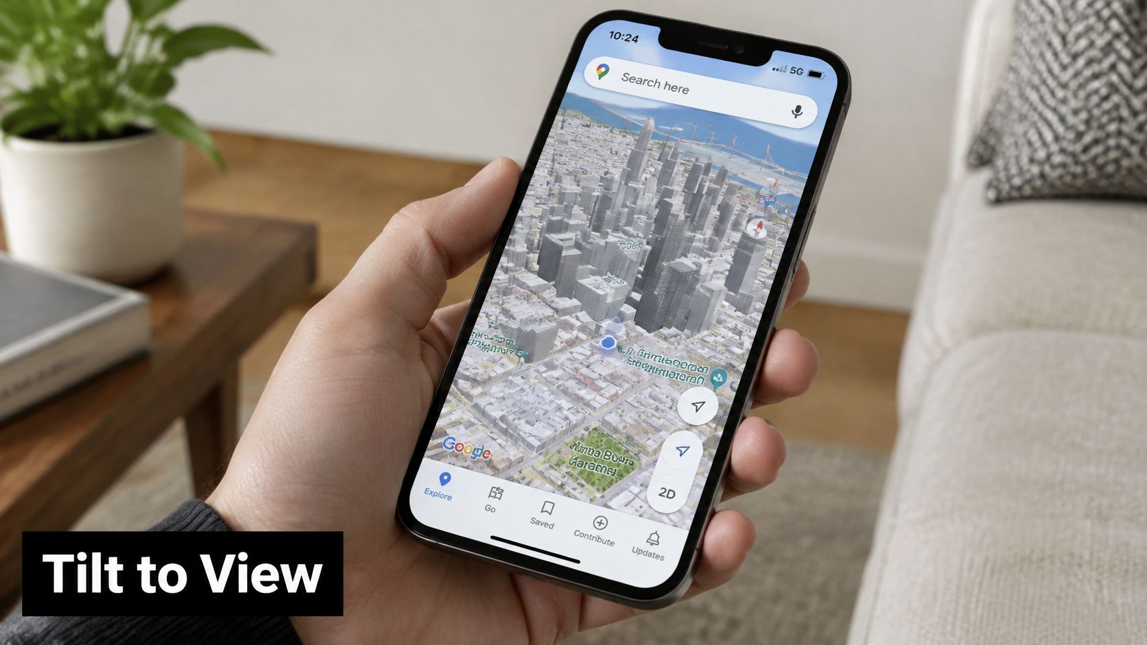
The Gesture Sequence
- Update the Google Maps app: An old app can ignore tilt gestures or behave inconsistently. Update first so you're not troubleshooting a version problem.
- Search a city center likely to have models: Choose a national capital or a large downtown, not a rural pin or a highway rest stop. Your first test needs covered buildings.
- Pinch-zoom until blocks are distinct: Spread two fingers apart until building footprints and side streets separate. If you can still see the whole city, you're too far out for meshes.
- Place two fingers on the map and swipe upward: This is the tilt. Both fingers move up together, tipping the camera from overhead toward street level. Swipe back down with two fingers to flatten the view again.
- Twist two fingers to rotate: Turn them like you're rotating a photograph on a table. Tap the compass when you want to snap back to north-up and regain your bearings.
- Switch to Satellite if the road map looks lifeless: Open the layers stack, choose Satellite, then tilt again. Imagery plus meshes usually reads better than pale road styling when you're judging real buildings.
- Walk the camera into position: Tip the view until the facade faces you, then rotate so the road runs the way you're standing. That alignment is what makes mobile 3D useful on a sidewalk.
Notice what's missing from that list. There's no Globe view switch and often no labeled 3D button on mobile. Buildings appear as a result of zoom plus coverage, not as a separate download or add-on. If a tutorial tells you to find Globe view in the Android or iPhone app, it's describing desktop.
Gestures That Get Confused
A one-finger swipe only pans. It slides the map north, south, east, or west, and it will never tilt the camera no matter how many times you repeat it. You need two fingers moving together for tilt and rotation.
Pinching is also different from tilting. Pinch changes distance. Tilt changes angle. A common mistake is zooming in harder when the view stays flat, which gives you a bigger flat rooftop instead of a facade. Zoom first to block level, then stop zooming and do the upward two-finger swipe.
If the picture gets larger but you still only see rooftops, you're zooming. If facades appear and the horizon tips into view, you're tilting.
Don't confuse ordinary tilt with other mobile tools. Live View walking arrows use your camera and point you along a route. Immersive fly-throughs are curated previews for selected places. If those buttons are missing for your destination, ordinary tilt can still work, because it depends on the map camera and city coverage, not on a special preview.
Portrait and horizontal view both work. Horizontal view gives your fingers more room for the twist gesture and shows more of a wide boulevard or plaza. Portrait is easier one-handed while you walk, though you'll tilt with a shorter swipe. Use whichever orientation lets you keep two fingers comfortably on the glass without covering the building you're inspecting.
Close with the height test. In a major city at deep zoom, tilt should reveal sides, shadows, and relative height. If rooftops stay painted flat after a proper deep zoom in a major downtown, stop repeating the gesture. Something else is wrong, and the fix list will identify it faster than another ten swipes.
Why the Map Stays Flat and How to Fix It
The usual false alarm looks like this. You did the clicks or the gesture correctly, the camera tilted, and the buildings still didn't stand up. You conclude 3D is broken. In many cases the place has no building mesh, so you're looking at correctly tilted imagery and calling it a failure.
Start with coverage, then work through settings. According to Google Maps Help on tilting and rotating the map, if 3D is unavailable the usual causes are Globe view being disabled, an unsupported browser configuration, or insufficient graphics capability. That short list explains most desktop failures, while zoom level and city coverage explain most mobile disappointment.
Flat Map Symptoms, Causes, and Fixes
| What you see | Likely cause | Fix |
|---|---|---|
| Zoomed-out desktop map is a flat sheet | Globe view is off | Layers, More, Globe view, then the 3D icon |
| No imagery and no height | Still on the default map | Switch to Satellite, then tilt or press 3D |
| Tilt works but buildings stay flat | Outside covered cities, or not zoomed in | Test a major downtown and zoom to block level |
| 3D icon missing or tiles turn black | Hardware acceleration or browser blocked | Turn on graphics acceleration or use Chrome, Edge, or Firefox |
| Buildings pop in late and look soft | Imagery is streamed on a slow connection | Wait, or zoom in smaller steps |
| Two-finger swipe does nothing | Old Google Maps app | Update the app, then tilt again |
| No Immersive fly-through button | That feature is limited to selected places | Use ordinary tilt and rotate instead |
Work the rows from the top. Globe view left off keeps zoomed-out desktop Maps as a flat projection, and users often stop there because the rest of the interface looks normal. Turn it on under Layers and More, then press 3D near the compass. The order matters, because the 3D experience builds on the globe-based view.
Staying on the default map is the next quiet failure. The road style is fine for labels and routes, but it hides the satellite imagery that makes meshes readable as real buildings. Switch to Satellite, zoom to block level, then tilt or press 3D again. Judge the result after that change, not before it.
When the Place Is the Problem
Zoom level and location fool more people than settings do. At citywide zoom, even a covered downtown shows flat polygons because individual models aren't drawn yet. Zoom until you can read street names and separate one block from the next. If buildings still stay flat there, test a major downtown you know is modeled before you blame your account, your phone, or your browser.
That test gives you a clean answer. If the known downtown stands up and your town doesn't, your setup works and your town lacks a mesh. If the known downtown also stays flat, you have a real settings, app, or graphics problem to fix. Don't skip this comparison, because it prevents hours of reinstalling apps for a coverage gap.
Browser, Connection, and App Causes
A missing 3D icon or black tiles on desktop usually points to graphics. Browser-based 3D rendering depends on WebGL-style hardware acceleration, so enable graphics acceleration in your browser settings or switch to a current version of Chrome, Edge, or Firefox. An old work laptop with acceleration disabled by policy can run flat Maps perfectly and still refuse 3D.
Slow loading looks different. Buildings pop in late, textures stay soft, and sharp detail arrives in patches because imagery is dynamically streamed as you move. Wait on one block instead of panning constantly, or zoom in smaller steps so each area finishes loading. A fast pan across a whole city on weak Wi-Fi will always look unfinished.
On phones, an outdated app is the simplest fix. If a two-finger upward swipe pans or does nothing after a deep zoom, update Google Maps and try the same downtown again. Don't change five settings at once. Update, retest one covered place, and check the height test.
Wanting Immersive View everywhere is the last trap. That feature is place-limited, so its missing button tells you nothing about ordinary tilt. Use tilt and rotate for everyday orientation, and treat a fly-through as a bonus where Google offers it.
Restate the pass condition before you declare victory. Buildings gain vertical geometry rather than remaining flat satellite polygons, and the tilt control changes camera perspective rather than only zooming. If both happen in a known covered city, your setup is correct. Any flat result elsewhere is coverage, not a broken control.
Test a Covered City Before You Explore
Don't make your hometown your first test. Start in a city known to be modeled, such as a large U.S. downtown or a national capital, and prove that your device, browser, and gestures work there. Then search the small town you care about. That order tells you the truth in under a minute.
If the capital stands up and the town stays flat, the app is working. The town lacks a mesh, and no reinstall will create one. If both stay flat, revisit the Satellite base, Globe view on desktop, zoom level, app update, or hardware acceleration, depending on your device.
Make a Working View Useful
- For a street decision: Rotate so the road matches the direction you face, then tilt until the facade fills the frame. You can now compare the entrance, neighboring storefronts, and the corner you'll approach from.
- For wider orientation: Zoom back only far enough to keep neighboring blocks in view. Pulling out to region level drops the buildings you worked to reveal.
- For roofs and parking: Stay on Satellite so lots, alleys, and roof shapes stay visible over the model.
- For readable labels: Use the default map when street names and transit markers must stay clear over the geometry.
Save the place once the angle is right. Saving lets you return to the same destination without rebuilding your search, even though you'll tilt again when you reopen it. That's handy when you're comparing hotels or venues across a trip, much like planning stops in advance with a practical itinerary for multigenerational LA trips before you check each neighborhood in 3D.
If Maps still looks thin after a fair test, open the same pin in Google Earth for fuller terrain. Earth is the better call for coastlines, hills, and approaches where land shape matters more than street labels.
Run one concrete test now. Desktop users should apply Satellite, Globe view, and 3D to a known city. Phone users should deep-zoom that same city and do the two-finger upward tilt. Judge both by the same standard. Vertical buildings and a real change in perspective mean you did it right.
If you're setting up the mapping, AI, and software tools you use for trip planning and everyday work, AccountShare helps you access premium services at reduced cost through secure group purchasing, with shared account management, password sharing options, and customizable permissions. Visit AccountShare to choose a tool, review the plan, and add it to your cart for checkout, so your team or family can keep the services you rely on without paying full price for each one separately.